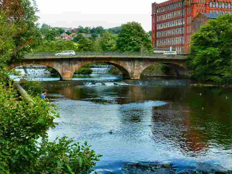
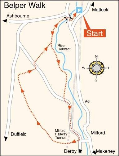
BELPER STRUTT HERITAGE WALK

Bridge Foot, Belper
Bridge Foot, Belper

THE WALK

Belper Strutt Heritage Walk takes you through ‘Strutt Country’. It sets off from the Riverside Gardens, past North Mill and along North Lane to Milford, another of the Strutt family’s strongholds. As you cross the bridge over the river at Belper at one time, the dam on the right incorporated 12 large water wheels, the housings of which remain.

The Strutt family’s influence is strongest in Milford. They owned the whole village and employed virtually all working-age inhabitants.

From the top of Sunny Hill, fine views of the industrialisation of the Derwent Valley are clearly in view. After leaving Milford, you return to Belper on the other side of the valley.

LOOK OUT FOR

Route Point 1 –The River Derwent flows more than 50 miles through the heart of Derbyshire. It provides the water power to run the mills along its valley. The Derwent Valley was awarded World Heritage Status in 2001 and is known as the ‘Cradle of the Industrial Revolution’.

Point 5 – North Lane is a former Roman Road that takes you along a ridge below Chevin Hill. The lane runs along a broad, tree-lined path, which is somewhat uneven in places. Walking along North Lane, you will see fantastic views across the Derwent Valley and wildlife to enjoy. One unusual feature is a high wall built by the side of the lane, which at one time was used for rifle target practice.

River Derwent Sluice, Belper
North Lane
North Lane

Point 6 – The rather strange-looking Tower at the top of Sunny Hill was initially considered a sighting point to help railway workers get the line of Milford Tunnel straight. However, following recent research, it is now believed that it was a semaphore point used to signal to drivers when the tunnel was clear.

Point 7 – Until the end of the eighteenth century, Milford was no more than a tiny settlement where lead miners from Wirksworth once forded the river. Although the houses and farms built by the Strutts’ remain largely intact, the former mills and most ancillary buildings no longer exist. The foundry remains, as does Milford Dye-house, built two years after the death of William Strutt. The tall round red-brick chimney dominating the site, built in the late 19th century, replaced an earlier construction.

Sunny Hill Tower
Sunny Hill Tower
Milford Chimney
Milford Chimney


Point 8 – The original Strutt family mansion, Milford House, is on Derby Road, but they later moved to Makeney Hall. The latter had a view over most of the workers’ houses in the village. Shutters protected nearly all the dwellings with holes drilled through them, so internal lights were visible from outside. When observed shining after 11:00 p.m., the tenants were warned the following day about the dangers of sleep loss.

Point 10 – On the river’s east side, the land rises steeply, where the workers’ cottages run along contours parallel with the road. The terraces are unusual in that they allow for the steeply sloping site with the houses on the east side two storeys high and on the west three. It enables all the dwellings to have the same accommodation. There were three east houses to every two west dwellings, even though they were back to back.

Makeney Hall
Makeney Hall
View Over Milford
View Over Milford

WALK DETAILS

Length: 6 miles.

Start: The Belper Strutt Heritage Walk from Riverside Gardens pay-and-display car park is a few yards north of the intersection of the A6 with the A517 Ashbourne Road on the north side of Belper. (SK345485) The railway station is at the rear of King Street, the main shopping street.

Terrain: A relatively easy walk along well-trodden paths and country tracks. There is some ascent and descent, but nothing too strenuous, although the walk down Sunny Hill at Milford is quite steep.

Refreshments:  The town has many cafés, pubs, and restaurants to suit all tastes. 

THE ROUTE

Belper Heritage Walk Map
Belper Strutt Heritage Walk

1. Leave the Riverside Gardens Car Park and walk between the River Derwent and North Mill to reach the A517. Turn right and cross the bridge. Once on the other side, immediately turn left down an access road running alongside the boundary fence to the river.
2. Where the road ends, go through a stile and continue over two fields, the boundaries of which are close to your left.
3. In the following field, keep close to the fence first before angling slightly towards the river. Follow the Derwent for about 200 yards until, with the end of the field clearly in view, you go through a squeeze stile on the right-hand side by a metal gate.
4. Angle to the left across two fields along a well-trodden path before following a paved path up a gulley into another field. Aim towards a fence at the top of the field. Cross a stile and walk down to Chevin Road, where you turn left.
5. After 200 yards, turn right at a fingerpost sign and ascend two fields, keeping close to the wall. At the top, turn left and walk along a wide track, North Lane, without deviating for approximately one mile.
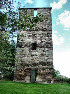
6. The track starts to bend to the left and is soon replaced by a tarmac road. You pass a high Tower before steeply descending Sunny Hill. 7. On reaching the foot of the hill, where Milford County Junior and Mixed Infant School stands, turn right along Chevin Road. After a few yards, go left down an access path in front of a row of cottages. Turn left at the bottom along the footpath by the A6 and walk through the centre of Milford.
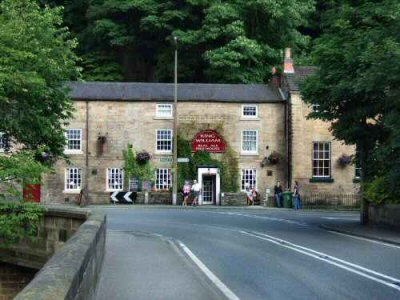
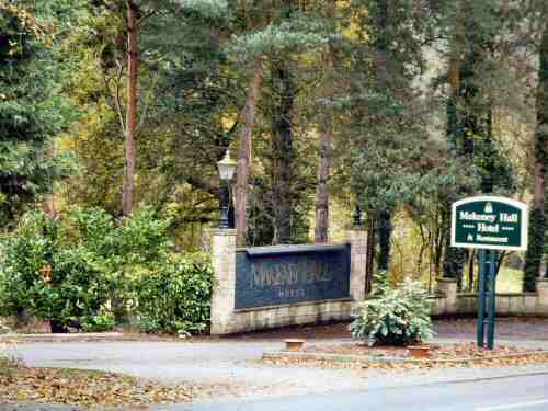
8. Take a sharp right up Makeney Road after crossing the river bridge. Continue walking along the pavement as it bends to the left. On the right is the drive to Makeney Hall, the former residence of the Strutt family. At this point, turn left up Holly Bush Lane, and at the top of the lane, with the Holly Bush Inn a short distance away on your right, go left up Dark Lane.

Ascending North Hill

9. At the end of a row of cottages, turn left at a finger post sign and walk up to the top of a field. Go to the left, keeping close to the field boundary and cross a stile in the corner. Follow the hedge around to the right to another stile. Continue along an enclosed path and cross a field angling about 45 degrees to the right.
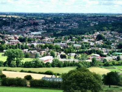
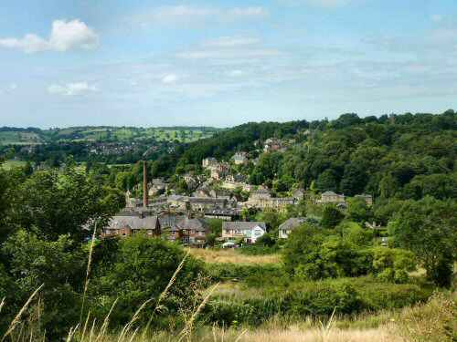
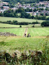
10. The route now follows an enclosed path through several fields to reach Shaw Lane. Go up the steps and follow an obvious path on the other side of the lane, which has excellent views of Milford and the Derwent Valley. Keep to the right of an area of woodland, at the end of which turn right towards Wildersley Hall Farm.
11. As you ascend the field, angle slightly to the left to reach Wildersley Lane. Turn left down the lane. When you reach Holbrook Road, turn right and walk up the road. When the road bends to the right, turn sharply left to follow a public footpath between houses and into the open countryside.
12. Keep straight on without deviating. After a short distance, the path starts to descend, with railings on your left. As you near the bottom of the slope, go through a gap in the railings and walk down the left-hand side of a recreation field to the bottom corner.
13. Turn right down the road, then left into Manor Road. Go to the right down a path between numbers 20 and 22 Manor Road. Follow the path to the right to reach Brookside, where you turn left along the road.
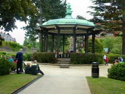
14. At the end of Brookside, turn right and walk a short distance up the A609 until just past Strutt Street. Go to the left, up a flight of steps into Belper War Memorial Park. Walk across the park, leave at the main entrance, and continue straight ahead along Green Lane.
15. At the end of Green Lane at a ‘T’ junction, turn left down Long Row. Turn right at the bottom of the road along the A6. The entrance to the car park where you started from is on the left side of the A6, behind East Mill. It is accessed almost immediately after passing the left turn for Ashbourne (A517).
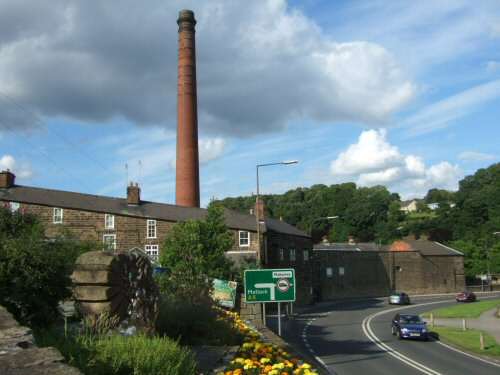
Belper

Belper from North Hill
King William, Milford
Belper River Gardens