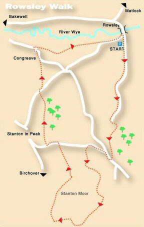
ROWSLEY AND STANTON MOOR WALK
THE WALK
Rowsley and Stanton Moor Walk is one of contrasts through beautiful limestone country with superb views. Crossing the isolated gritstone plateau of Stanton Moor, covered with its Bronze Age relics.
Climbing up steadily from Rowsley on a circuitous route, you eventually reach the edge of Stanton Moor. The path follows the edge of the moor around, providing fantastic views and passing Earl Grey’s Tower that commemorates his Reform Act of 1832.
Last century, the Heathcote family excavated in excess of 70 burial mounds on the moor. The most famous of the Bronze Age relics is the Nine Ladies Stone Circle.
On the edge of Stanton in the Peak, your route takes you past the local cricket ground that must have one of the prettiest views in the country. From there, you pass through fields with the River Wye getting ever closer before arriving back in Rowsley.
LOOK OUT FOR
Route Point 3 – In 2005, environmentalists won the battle in a long-running dispute over quarrying at Endcliffe Quarry, located near the historic Nine Ladies stone circle on Stanton Moor. When the Court of Appeal ruled that the quarry and Lees Cross Quarry should remain “dormant”. Protesters had been living in trees and tunnels at the site for five years to prevent any more quarrying. Stancliffe Stone, the quarry owner, eventually agreed to give up its planning permission for the site in return for permission to work Dale View quarry. The local authority said the deal would protect a valuable part of the park and surrounding heritage sites, and the legal documents were signed and exchanged.
Point 4 – The Earl Grey Tower, erected by the Thornhill family of Stanton-in-Peak, sits on the edge of the moor. It commemorates the passing of the Reform Bill in 1832. At the first hearing of the Reform Bill in Parliament, only 5% of the population of England, Scotland and Wales had the right to vote, which was considered by many as unjust. There were constituencies with only a few voters who had two MPs, and others much larger, with none. Ballots were not secret, and as a result, candidates bought votes, usually through the provision of free beer. The Bill was passed by the House of Commons but thrown out by the House of Lords. Rioting followed, which resulted in the passing of the Bill the following year.
Point 5 – The Cork Stone on the south side of the moor is one of several impressive natural outcrops on the moor. A natural pillar about 15 feet high: it has iron footrests driven into it for those who want to climb to the top. Composed of weathered sandstone, it resembles a giant cork. There are a number of these blocks of granite scattered about the moor, made of a much harder rock than the plateau.
Point 6 – Stanton Moor is famous for its Bronze Age relics, the best known are The Nine Ladies Stone Circle, a low circle of worn gritstone blocks in a striking location, near the centre of the moor. On the southern edge of the circle is a small standing stone, known as the King’s Stone. Legend has it that the nine ladies danced here on the Sabbath Day and were turned to Stone as a punishment, along with the fiddler (King’s Stone) who stands nearby. The moor contains at least 70 barrows as well as stone circles, ancient enclosures and standing stones and is of immense interest to archaeologists.
Point 7 – On the edge of Stanton-in-Peak, your route takes you past the local cricket ground (named Stanton-in-the-Peak, which differs slightly from the name of the village) that must have one of the prettiest views in the country. You might want to take a short detour from your walk to visit, particularly if there is a match in progress. Specsavers recently sponsored the new club shirts, so there should be no reason for the players being unable to see the ball properly, however quickly it might arrive!
Point 8 – Built by the Thornhills of Stanton-in-Peak, The Stand, was originally known as The Belvedere. It is a viewing platform with a stone seat, situated along the road to Rowsley, from where you get a magnificent panoramic view over the beautiful valley where the River Bradford joins the Wye at Fillyford Bridge. To the east, in an elevated position above the River Wye, Congreave is a small hamlet consisting of just three properties: Congreave Farm, which is a listed building, Dove House Farm and, most significantly historically, Stanton Old Hall, which is also listed. The Old Hall predates today’s Stanton Hall in the village by several centuries.
WALK DETAILS
Length: 5.50 miles.
Start: Roadside pull-in by the Recreation Ground on the road to Stanton.
Location: On the A6 between Matlock and Bakewell, approached from the south, you turn left opposite The Peacock Hotel and follow a minor road around over the River Wye Bridge. As the road bends sharply to the right, if you have travelled by car, look out for a parking space opposite Rowsley Recreation Ground.
Terrain: Steep in places, but nothing too strenuous along well-trodden paths. Stanton Moor is very straightforward to cross, but as there are several tracks, please ensure you do not miss any of the landmarks mentioned.
Refreshments: Pub, restaurant, and café meals are available in Rowsley as well as at the Shopping Village.
THE ROUTE
1. From the car park, follow the private lane by a footpath sign towards Stanton Lees and continue along the lane as it gradually climbs through Holly Wood. Leave the lane to the right at a footpath sign and keep close to the wall on the left to climb a short hill.

2. Take the next footpath sign on the left and immediately bear right onto a stony track leading past Stanton Woodhouse Cottages and Farm. Pass through the metal gate in front of you into a field where the track bends to the right.
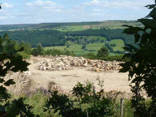
3. Go through an open gateway and follow the path as it bends to the right past Endcliffe Quarry, which is now redundant. On reaching a stile onto a minor road, turn right and shortly afterwards at a ‘T’ junction of roads, turn left to walk uphill.
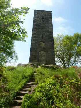
4. After about 300 yards, go over a wall stile on the left and cross a short field to enter a wood. Angle to the right and continue alongside the wall to follow the main track alongside Stanton Edge, past Earl Grey Tower and continue along the moorland edge.
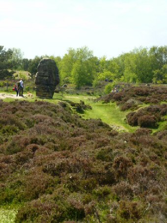
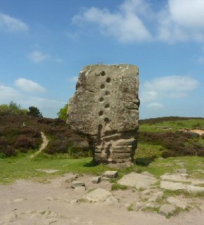
5. On reaching a National Trust sign, opposite a viewpoint, go over a stile on the right and continue up the slope before turning left to follow a path close to the side of the moor. At the Cork Stone (easily recognisable by its footholds and handgrips), turn right and when the track divides, keep to the right.
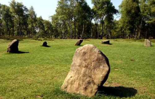
6. After about half a mile, keep on the main path passing the Nine Ladies Stone Circle. Continue ahead along a distinct path through woodland and two fields to reach Lees Road.
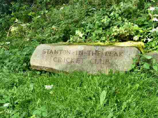
7. Where you turn left for 250 yards along the road, and just before entering Stanton village, take the footpath sign on the right to walk along a rough surfaced path, past the village cricket ground, and follow the path that keeps to the western edge of Sheepwalk Wood.
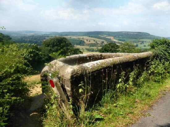
8. At a yellow waymarked arrow, turn left out of the wood to descend a short path to Pilhough Lane. Turn right and walk past a viewpoint sitting area, The Stand, to a stile on the left. After crossing the stile, turn right and walk downhill to follow a line of trees to a stile.
9. Continue ahead with the field boundary on your right to go over a stile by a metal gate. Turn left down the road into the small hamlet of Congreave. Opposite Dove House Farm, turn right along a track to a squeezer stile. Follow the path to the right as it leads around the base of the hill to a stile in the far corner.
10. Go through two gate stiles in quick succession into a small wood. Then cross the next field, angling slightly to the right, close to a line of trees, to join a green farm track. The grassy track eventually takes you to the water’s edge and along a farm track to a wooden fence stile by a metal gate to gain access to the road, turn left towards Rowsley and the starting point of the walk.
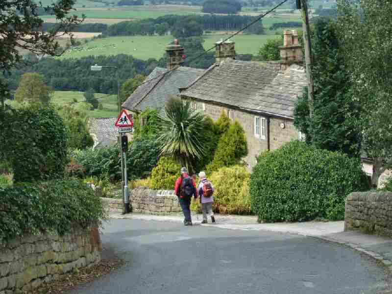
ROWSLEY